Saturday, October 13, 2012

Day 38 (A Travel day) Santa Fe, NM - Amarillo, TX 278.3 miles, New Total = 7,438.4 miles
Yesterday was a long day and a long post, but I didn't take the time to talk about the Albuquerque Balloon Festival which was going on all last week. We found this out on our way to santa Fe and decided to find a way to go.  When we arrived Thurs. afternoon the weather in Santa Fe was overcast and windy and upon checking the TV channel for Albuquerque, we found out that the evenings activities were cancelled due to wind. The forecast for the morning was worse with rain, wind & thunderstorms predicted. We decided to wait until Saturday.  They were in fact cancelled Friday morning (rain & lightning) and Friday evening (wind).  After our adventure with rain & hail & wind late friday afternoon and the forecast of storms throughout the evening, we were very skeptical about Sat. AM.  The forecast called for light but increasing winds and the morning ascension was still in doubt.  After much discussion, we opted to forego the Festival and move on to Amarillo. (It was 65 miles the opposite direction and we doubted we we could do that and our scheduled drive comfortably in the one day.)
 The drive to Amarillo was basically interstate most of the way.  The scenery was trucks, trains & mostly flat open spaces.
Welcome back to the interstate

We did see some interesting adobe houses before we left New Mexico.
a nice adobe1


Jan did a 10 minute truck count and got 45 trucks in the westbound lane.  I multiplied this by two to account for the eastbound lane we were on, and then by six to get the amount per hour. This says there were probably over 500 trucks passing this point in one hour. It made sense based on our observations.
Long trains (too long to count) were also quite in evidence.  Many were double decker container trains with well over 50 cars.
...one of many westbound trains

I know this is kind of boring, but driving the interstate is!  Oh yeah, we did see a lot of cattle dispersed throughout these open spaces, and one stockyard close to the highway that we found out the hard way really stunk!!  Upon opening the side window to take a picture, we were blasted with a horrendous aroma, and it smelled more like an open sewer more than a normal manure aroma.

stockyard!

The day was very windy, luckily on our backs as we were driving, but at lunch and when we arrived at the campground, it was pretty much intolerable to sit out.  Jan set down her sandwich and unpeeled banana on a paper plate and before she could sit down to eat it, the wind blew it off the table onto the ground.  Our KOA for the night was just beyond the center of the city and close to the airport (quite common) and a major rail line with a couple of road crossings close by.  (we heard no less than a dozen  trains during the night, announcing their passing with 5 whistle blasts)  Luckily I grew up next to the tracks so it quickly became just background noise.

Friday, October 12, 2012

Day 37 (Sightseeing in Santa Fe & the Pecos National Historic Park) 75 miles, New Total = 7,160.1 miles
In the morning we drove to downtown Santa Fe and had our "steeds" serviced at a Jiffy Lube.  Out in less than an hour total for the two of us and on to the Old Town District of Santa Fe.  Nicely the city has a public parking lot designated for Busses & RV's right in the district.  Our first destination was the State Visitor Center, but on the way we passed The San Miguel Mission (billed as the Country's oldest church)
 

 and the Oldest House in the US? built around 1612.


 We then moved on across the street to The State Capital, known as the Round House, due to its shape.  It was designed to resemble the State's Zia symbol when viewed from the sky.

There are 3 floors of contemporary masterworks of art by artists who live and work in NewMexico.

  We then toured about 4 or 5 blocks of shops of all kinds, including jewelry, clothing, leatherwork and other SW products. Our walk also took us by the 134 year old Loretta Chapel (known for its miraculous staircase) and the stately Cathedral Basilica of St Francis of Assissi built between 1869 & 1887.


With our parking permit running out @ 2:30 we returned to the campground to drop off Dave's motorhome and head to Pecos NHP.  The pueblo ruins date back to 800 A.D. for its earliest inhabitants.

As we arrived at the Park it began to shower and thunder was heard in the distance.  Jan was firm, she wanted to take the 1.3 mile hike through the ruins, (Pecos pueblo and Mission Church) so we exited the visitor center quickly and started our walk.  (No one had rain gear).  It was an enjoyable walk, with narration by Jan from a prepared set of cards we were given at the visitor center.


The walk was slightly uphill and we soon found ourselves atop the old ruins with more thunder and raindrops in the air.  We continued and returned to the visitor center, crossing a segment of the Old Santa Fe Trail on the way, for a short film and brief tour of the museum on site. We luckily exited the Park with only a few drops of rain in the air but the wind was stiff and the sky was very threatening.  We drove the 5 miles back to I25 with only a slight increase in the rain, but we were no sooner up to speed on the highway when Mother Nature let loose.  Driving rain with intermixed hail came down in sheets and I quickly slowed to 40 despite the 75 MPH speed limit. After 10-15 minutes of 3-4 showers of this nature, the road was so covered with hail that most drivers were pulling to the side of the road and stopping. It looked like a typical NE snowstorm with about an inch or so of snow(but it was ice balls about 1-1.5 inches) covering the surface except where the tires of the vehicles had crushed the hail. Being a seasoned New Englander, I proceeded gingerly and didn't stop until we got on our exit ramp so we could take some pictures of the ground.

By the time we reached the campground about 3 miles further on, the hail was gone except under the bushes here and there. The evening continued with wind & rain and we solemnly listened to the TV weather reports of potential tornados in the area. The warnings expired and we went to sleep with only a mild nervousness. We did ask ourselves though, where would you go if there was a sighted cloud in an area with no underground structures of any kind and our only transportation was tethered to the ground with electrical and water connections?

Thursday, October 11, 2012

Day 36 (A Traveling Day) Durango, CO - Santa Fe, NM  220.7 miles, New Total = 7084.9 miles
Took the scenic route East through CO for a while on Rte 160 to Pagosa Springs, then South on Rte 84 through the San Juan Mountains and the Santa Fe National Forest.  Crossed the Continental Divide (probably for the last time) just after we entered New Mexico.  This road south was a really nice 55mph secondary road with almost no traffic and abundant views of the San Juans and the rolling land.
Relaxing roadside views

The San Juan Mountains


Stopped for lunch at a roadside rest area overlooking Abiquiu River as it widens before the Abiquiu Dam.  Across the road were some more of the beautiful SW red rock cliffs also.
Abiquiu Lake below the Dam


We didn't see much of character of Santa Fe as the road took us through a commercial & residential section of the city which could have been any typical city of the West or the East.(with the exception that we started to see adobe architecture)  Then it was on to the KOA on the East side of Santa Fe.

Wednesday, October 10, 2012

Day 35 ( Sightseeing in Durango, CO)  0 miles, Total still = 6,863.7 miles
My son Craig drove down from Carbondale, CO, where he is temporarily residing while looking for a job in CO.  He came down last night and Jan and I went with him into Durango and had supper at a Brew pub where a friend of his works. He spent the night in Dave's camper as ours is really a (2) person unit. This morning the five of us loaded into his rental car and drove up into the mountains north of Durango.  We thought we had seen enough mountains already, but the CO mountains are unique in their own way.  Many of the Aspens had already dropped their leaves, but not all and we were treated to some beautiful sights.


Mix this with some early snow on some of the peaks and you have a great combination.


 We drove up to Cold Bank Pass Summit (10,6660') and saw some great peaks.

Then we continued on to Molas Pass (10,899') and saw some even better views.


Returning to Durango (which sits at about 6500') we had lunch at a great little restaurant (Ken & Sue's) on Main Street and then walked the old time Main Street and window shopped. After going back to our campground (at 7000') we spent the remainder of the afternoon catching up on his job search and other adventures in CO. In the evening the five of us had a very competitive game of Cosmic Whimp-out.  Jan and I were left in the CO dust while Dave and Craig were victors for the night.

Tuesday, October 9, 2012

Day 34 ( A Travel day) Page, AZ - Durango, CO 271.5 miles, New Total = 6863.7 miles

Today we're driving to Southern Colorado to meet my son Craig who is temporarily living there.  Our trip will take us through the heart of the Navajo Nation Reservation and just South of Monument Valley.  Our intermediate destination is The Four Corners. The intersection of the states of Utah, Arizona, Colorado & New Mexico. This is the only place in the US where the borders of 4 states cross at one point.  Again much of the land we are traveling through is desert, but the flora changes with the altitude.
low desert scrub

scrub size increases with altitude


We reached The Four Corners at just about lunchtime and spent about an hour taking some photos and viewing the many Navajo vendors who were selling native american crafts.
(4) Travelers in (4) States


We had a particularly enriching experience talking with one young Navajo who was selling handmade arrows and other native weapons.  He turned out to be a medicine man, in training under the leadership of his grandfather who was in his mid nineties. He was told that his grandfather performed a ritual on him when he was a baby to put him on this path. He explained that although most white men and navajos believe the Dineh  is the name for the navajo people, that the true meaning is all of they who walk upright upon this earth who have 10 fingers & toes.  His grandfather told him his role as a medicine man as such, was to serve all peoples regardless of the color of their skin.


As I said our talk was very enriching.  After lunch we motored on into Colorado.  About 10 miles later I had my 2nd minor mechanical problem of the trip. My generator exhaust pipe separated from the generator and was dragging on the roadway.  I heard it almost immediately and pulled over and was able to unbolt it from its hanger and we were on our way in less than 10 minutes.  We haven't had the need to use the generator on the whole trip so i may not reinstall it until we get home.

Monday, October 8, 2012

Day 33 (Sightseeing & Travel Day) Panguitch, UT - Page, AZ (Incl visit to Zion National Park)
191.8 miles, New Total = 6592.2 miles.
Drove about 40 miles to Zion from the campground.  Saw a number of mule deer on the roads.


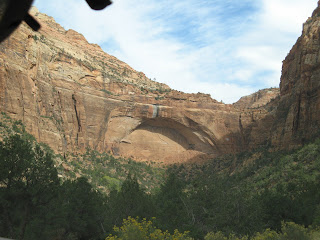
Also a small herd of Buffalo.  The road into the Park Visitor Ctr. had some fabulous scenery, breathtaking switchbacks, and a one mile tunnel carved through the sandstone mountain.

 From the Visitor Ctr. we took the Park free shuttle to the various viewpoints along the twelve mile Park central canyon road.  Our first stop (at the far end of the Canyon) was the Temple of Sinawava where we took a mile walk up a trail along the Virgin River which runs through the center of the Canyon. This is the river that carved the Canyon over the millennia. In direct contrast to Bryce Canyon, Zion is viewed from the floor of the Canyon rather than the rim.


Along our walk, we viewed wildlife (mule deer, chipmunks, & squirrels), swamps, cottonwoods & aspens in color and of course the river.

We then boarded the shuttle again and stopped at 2 or 3 other scenic viewpoints and had lunch at the Zion Lodge.


  The ride out of the park through the many switchbacks was much more enjoyable for Dave and I as drivers.  We then traveled about 20 miles to Page, AZ where we were camping for the night.  Page is the home of the Glen Powell Dam and the Southern end of Lake Powell.

Sunday, October 7, 2012

Day 32 (Sightseeing at Bryce Canyon) (Dave drove 44.0 miles) New Total = 6,444.4 miles
Today was a day to visit Bryce National Park located in SW Utah.  The drive from the campground was about 20 miles and basically a high plateau, mixed grassland and stoney foothills. Our plan was to take one motorhome to the Park and use the free Park Shuttle to move within the Park. On one section of the road approaching, we passed through Red Canyon/National Scenic Byway 12 an unplanned treat.  A section of about 2-3 miles of breathtaking red rock cliffs along the road.


 When we entered the Park from Bryce canyon City, where we parked the Rv and picked up the shuttle, we first stopped at The Visitor Center and picked up some detailed Park info and quickly viewed the small museum.  It was devoted primarily to the wildlife & geology of the Park and the Southern Utah/Northern Az area.
Next the Shuttle took us to the highest viewpoint in the Park (Bryce Point) where we departed the bus for a quick view. (So we thought).

 Two hours and 1.5 miles later we rejoined the shuttle at Inspiration Point.  We had decided to walk the Rim Trail along the Canyon and wow!! We were walking and climbing at an altitude from 8335' up & down to 8100' and the views were unbelievable.

This is a Hoodoo!


 I think I took 100 pictures. We may have been the slowest on the trail, but no one enjoyed it more than we did.  We traveled to Sunset Point and departed the bus again for more views of this spectacular canyon.


We returned to the Visitor Center for a few momentos and headed for a late lunch outside the Park.

Our remaining afternoon at the campground was spent talking with our hosts (new owners of the KOA) and catching up on our blogs/scrapbooks, etc. After making our reservations for the next night, we retired to our RV's for dinner and sleep.